Celebrating 15 years family owned, OPERATING IN MAINE, USA
Raven Map of Maine topographical map
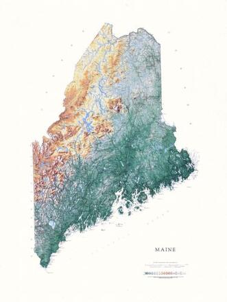
Raven Map of Maine topographical map
This spectacular topographic map of Maine features subtle hues of green, tan and brown to show the differences in elevation throughout the state, from the lowest point of sea level at the Atlantic, to Mount Katahdin at 5,267’ in Baxter State Park. This full size version measures 36" x 48", ARTiPLAQ-mounted, ready to hang on the wall, frame free, with no glare and no glass, looks especilly great with a gold edge! (Note: We can crop some of the white border to save on shipping costs, and it still looks awesome! Just note, "Plz crop to 33" x 44"" in comments at checkout.
Dimensions:
36 x 48
- We accept:


ARTiPLAQ™ is a family-owned company in Maine providing
exceptional quality custom plaque mounting. Made in the USA.
© ARTiPLAQ™ Terms of Use Privacy Policy